 A wildlife record is only useful if we know where the plant or animal was seen, and grid references are the best way of doing this. But why do we need to use grid references? Surely a place name will identify the location on the map? Well in many cases it can help, but grid references allow us to be more accurate. And, if you’re in a very rural area, the nearest town, village or settlement may be some distance from where you made your sighting.
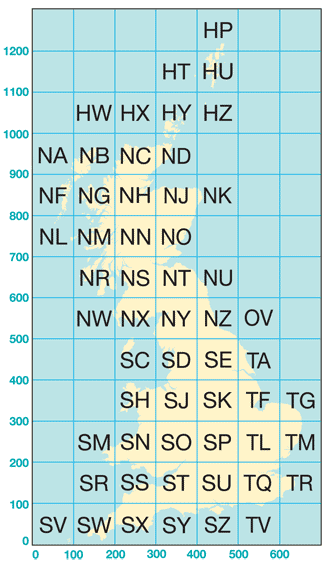
The whole country is divided into squares 100km x 100km. Each of these are labelled with two letters, which form the first part of every National Grid Reference. In Ayrshire, all grid references fall within three squares – NR, NX and NS. Dumfries and Galloway overlaps five squares – NW, NX, NY, NS and NT.
Each of these 100km x 100km squares can be further subdivided into smaller squares 10km x 10km, and these in turn are subdivided into 1km squares. These subdivisions form the grid of lines marked on Ordnance Survey maps, and each one is numbered along the edge of the map. Reading the numbers from the grid combined with the letters for the 100km squares forms a grid reference.
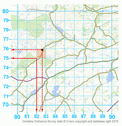
Suppose we have made a record at the circle on the map. First we need to look up the letter of the square – an OS Landranger (pink) or Explorer (Orange/Yellow) map will give the letter in each corner of the map. Be aware that some maps overlap more than one square so check carefully which square your site falls in. The example given here is from square NX. Find your site and follow the vertical blue line directly to the left of the site to the top or bottom of the page. This number is the ‘eastings’. In our example this is 82 (solid red arrow on map). Find your site again and follow the horizontal blue line directly below you site and follow this to the left or right of the page. This number is the ‘northings’. For Glen this is 75. Therefore to give a grid reference we put these together by giving grid square, then eastings, then northings making NX8275. This is called a four-figure grid reference and is accurate to 1km. In effect, all places in the red shaded square will give the same four-figure grid reference. To be a little more accurate, we can estimate how many tenths along our site is for our eastings and northings. So for Glen in our example the eastings would be 82 and 6 tenths and northings 75 and 9 tenths (dotted arrows). This would give a more precise grid reference of NX826759 – a six-figure grid reference.
Now there are many ways of looking up a grid reference online. Our favourite sites for doing this are Grab-a-grid-reference (Bedfordshire Natural History Society), Cucaera Grid Reference Plotter, Where’s the path? and the UK Grid Reference Finder. All allow you to get a grid reference by clicking on a map.
If you enter your records online through our online recording form or through sites such as iRecord you can similarly use the map tools to generate a grid reference for you when you enter your records.
SUP is registered in Scotland as a company limited by guarantee with charitable status. Registered address: The Southern Uplands Partnership, Studio 2, Lindean Mill, Galashiels, TD1 3PE. Company No. SC200827 / Charity No. SCO29475
